
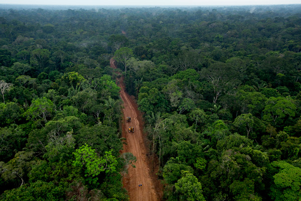
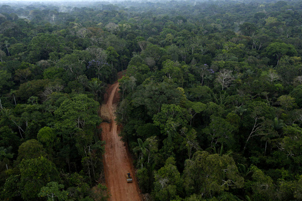
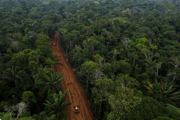
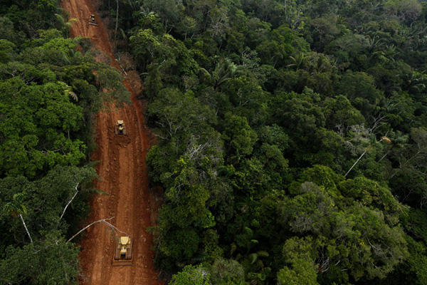
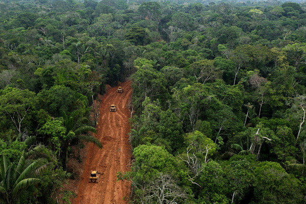
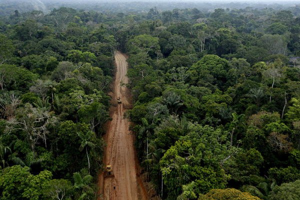
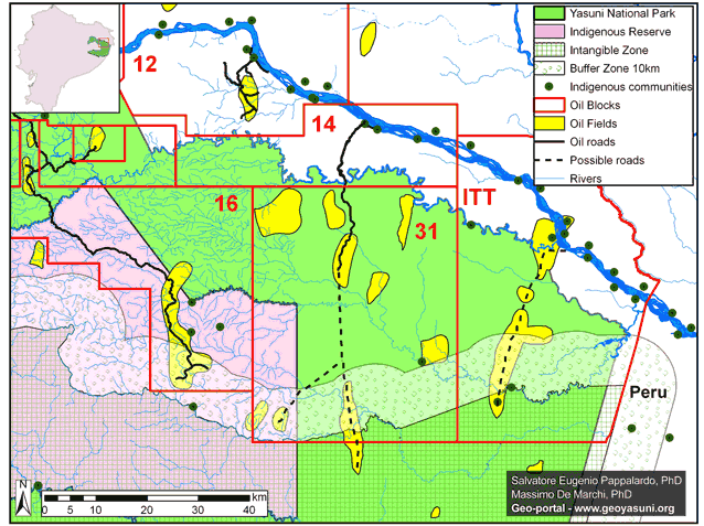
In August 2012, professional photographers Ivan Kashinsky and Karla Gachet were on assignment for National Geographic in Yasuní National Park, home to arguably the most biodiverse rainforest in the world. While there, they happened to take an aerial shoot above an area known as Block 31 (see map below), a controversial oil concession located in the heart of the park, at the precise moment that the national oil company, Petroamazonas, was secretly building a new oil access road.
In their January 2013 issue highlighting the park’s biodiversity, National Geographic published just one of these photos, leaving many compelling images out of the public eye. Here we present a striking collection of previously unpublished photos, providing a birds-eye view of industrial incursion into the core of one of the most important protected areas in the world.
These photos are particularly critical at this moment because, following the high-profile failure of the Yasuni-ITT Initiative, we believe that Petroamazonas is planning to build more roads of this type even deeper into the park. Here is the basis of our concern:
It is well documented that roads are the leading driver of tropical deforestation, particularly in the Ecuadorian Amazon. New access roads trigger a cascade of uncontrollable secondary socio-environmental impacts – such as colonization, illegal logging and over-hunting – that ultimately lead to habitat fragmentation and ecosystem degradation.
In recent testimony before a Congressional commission, Ecuadorian officials, including the head of Petroamazonas, were arguing for permission to expand drilling operations deeper into Block 31 and the adjacent ITT Block. Since these areas are within a national park, Congress must declare the projects to be in the national interest before they can proceed. To allay fears, the officials claimed that they won’t build new “access roads” into Blocks 31 and ITT. Instead, they will only use “ecological trails.”
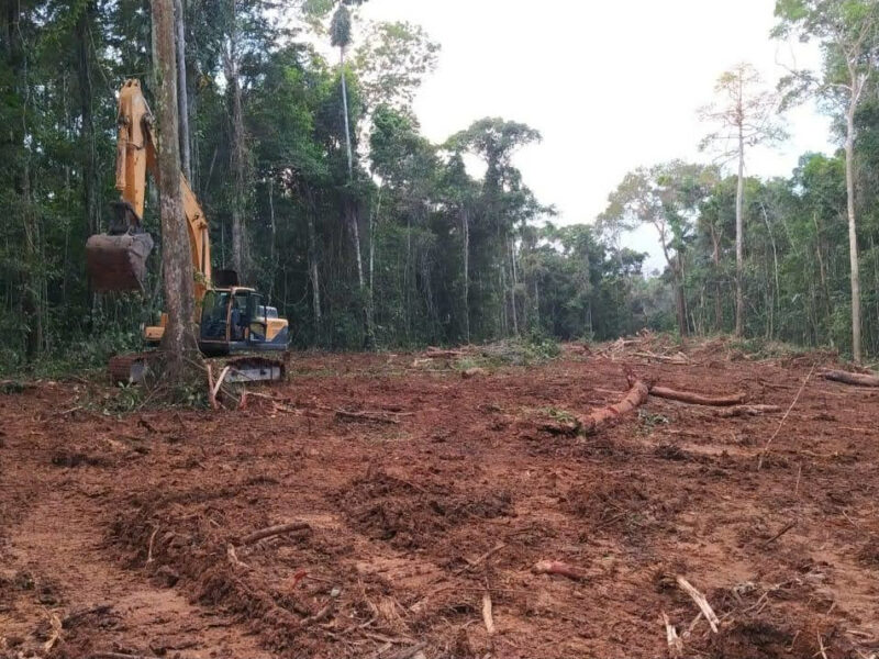
This assertion of course begs the question: What exactly is an ecological trail and is it as green as it sounds? In a recent document submitted to Congress, Ecuadorian officials described the access route built in Block 31 in 2012 as an “ecological trail” as well. Thus, we can analyze these newly released photos to determine whether this route is indeed a low-impact trail, or just another destructive access road with a greener name.
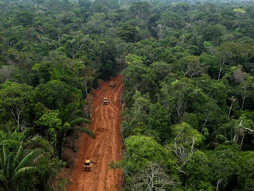
Unfortunately, we argue that the six new photos presented here point to the latter. Note that Photo 1 shows two workers walking on the path. Using them as scale, it is clear that the path is much more road than trail. Furthermore, the heavy machinery shown in Photos 2 – 6 also confirm we are dealing with a road and not a trail.
These photos highlight another critical problem: the threat to the Tagaeri and Taromenane, the semi-nomadic indigenous people living in voluntary isolation deep in Yasuní. In 1999, Ecuador created an “Intangible Zone,” an area off-limits to oil extraction to protect their territory from the expanding oil frontier. However, we fear that Petroamazonas plans to extend these new access roads to the very doorstep of the Intangible Zone in order to drill the remaining untapped oil fields in Blocks 31 and ITT (see map below).
Petroamazonas has already demonstrated it has no problem building new access roads through megadiverse, primary rainforest. In addition to Block 31, they have also been building new roads just north of the park in another concession known as Block 12. Our recent satellite imagery analysis reveals that Petroamazonas has built 13 km of new access roads in Block 12 between 2009 and 2011. The southern-most new road is now just 2.5 km from the Yasuni National Park boundary and less than 5 km from the renowned Tiputini Biodiversity Station. This station is one of the most important research centers in Amazonia, but scientific investigations have already been impaired by industrial noise pollution from the new Petroamazonas operations. The proximity of this road to the station is also facilitating access to hunters to exploit fauna within the lands allocated in stewardship to this institution.
In summary, until Ecuador provides detailed technical information to the contrary, we can only conclude that Petroamazonas plans on building more destructive access roads, like the one documented in these newly released photos, deeper into Yasuní National Park.
More information about the work of Ivan Kashinsky and Karla Gachet can be seen here: